Sully & The CDT

UPDATE from 9/20/19

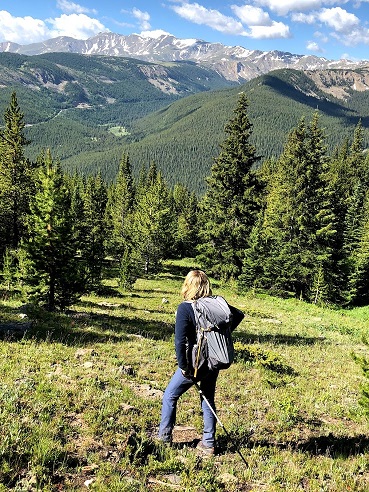
Here is a review of the last 2,604 miles over 5 months and 3 days… I hope you enjoy some of these views and it encourages folks to get out there. It’s so beautiful.

Stay tuned as I’ll be posting a bit about the funds raised for the ECA, GBU, and CDTC as well as re-entry and seeing my closest family members for the first time in months. It’s all so bittersweet…

Thank you everyone for your love and support on what might be the world’s longest walkathon!

Well, it’s been about 14 years since a 14,000 mile bike ride through 14 countries to reduce our impact.

Let’s go on another adventure and try to raise at least $14,000 to help continue that change!

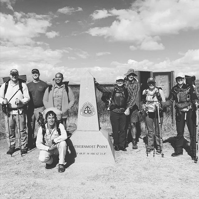
On the morning of April 17th, I’ll take a shuttle to the Southern Terminus of the Continental Divide Trail and attempt to hike 2,716 miles northbound to the border of Glacier National Park and Canada’s Waterton Lakes. Follow my journey here and/or on Instagram: energy_sullivan

 
CT trail June 2018_smaller.jpg

Be A Part of the Journey!

So, if you are going to be in any of the 4 states where I will be hiking this summer, please consider being my, or any other hiker’s, trail angel! A trail angel is a good Samaritan that provides some sort of assistance to long-distance hikers. If you’ve never heard of this term, here are some tips on how to be a magical one. Or perhaps you want to come and meet up for a day hike? Let me know!

One of the best ways you can make this journey better is to help me raise some funds for 3 local non profits described below. There is also an option to donate to my logistics and help me keep up the website and information flow, but I should need little for that. If I get more than I need, I will roll it back across the three non profits evenly.

Why Am I Doing This?

I’m doing this because I can’t sit still and I like scaring the living daylights out of myself. I’m learning to understand that the discomfort of being afraid keeps me alive inside.

The Onion has been one of my openly fake news sources that has kept me smiling over the last few years. This satirical article does a good job of summing up some of the conversations I’ve been having with friends and loved ones!

In addition, I want to make this bigger than just me and my love for the outdoors. I am trying to help 3 amazing organizations that I believe in. These non-profits are working for the greater good on shoestring budgets. After you click the donate button, you will be able to apply your donation to one or all of the options!


SAVE

Energy Coordinating Agency

ECA is a regional leader in energy efficiency retrofits for existing residential properties. They help low income families increase energy efficiency, lowering their energy bills.

Learn More

PROTECT

Continental Divide Trail Coalition

The CDTC promotes & protects the trail by building a strong & diverse trail community, and encouraging conservation and stewardship of this corridor and surrounding landscapes.

Learn More

BUILD

Green Building United

GBU promotes the development of sustainable, resilient, healthy, and cost effective buildings. They work to transform the way buildings & communities are designed, built, and operated.

Learn More

SUPPORT

Sullivan’s Logistics

While I prefer you donate to one of the non-profits I’ve listed, I won’t say no to some support to cover some costs of resupply logistics or vitamin supplements for these old bones, but more so website development and transaction fees. Thank you!

When you click any donation button, you will be able to designate what percent of your donation should go to which cause. You will have the option to pledge per mile, but remember, I am hoping to hike 2,700 miles. You don’t want to end up like Michael Scott from The Office.

Thank you!

The Hike

Take a look at the map to see where I will be going. You can also follow along with my journey!


2716

Miles to Hike

I am taking the shortest possible route and every short cut I can! I was hoping to thru hike continuously from NM to northern MT, but I may skip CO and come back later in the summer.

4200

minimum altitude

As you can see in the elevation profile, Colorado has a lot to offer! With the record snowfall occurring as we speak, this will be uncomfortable, but not impossible especially if I wait to tackle CO in August.

8

Apps I’ll be using on my phone

These apps will likely be my mainstays during the hike: Guthook, Earthmate, Messages, Camera, Instagram, Google Drive, Yelp, and Podcasts. My phone and GPS will be charged with my Anker PowerCore 20100, weighing in at 13 oz., same as my tent!

Here is what the elevation looks like throughout the course of the hike. The original plan was to start in NM and thru hike to MT. However, with the amount of snow we’ve gotten this winter, I may skip up to WY, coming back to those high altitudes of…

Here is what the elevation looks like throughout the course of the hike. The original plan was to start in NM and thru hike to MT. However, with the amount of snow we’ve gotten this winter, I may skip up to WY, coming back to those high altitudes of CO after some of the snow has melted. The good news is, there will be plenty of water!

Follow Along

See exactly where I am during my adventure with this interactive map and check out my itinerary here!

Follow me on Instagram at “energy_sullivan” or keep an eye on updates of the trip below.